|
Trails
1. Horteri Trail (Circular)
Starting Point: "Platanouthkia" site, about halfway on the Stavros
tis Psokas - Selladi tou Stavrou road. Initially, the trail follows an
upward course and can be tiring, especially in summer.
Length: 5 kms Time: 2 hours
Points of interest: An outstanding view of the valley of Stavros and Forest
Station. Near the starting point is a spring with drinking water.
2.
Selladi tou Stavrou Trail (Circular)
Starting point: Selladi tou Stavrou,
Length: 2.6 kms Time: 1 hour.
3.
Selladi tou Stavrou- Heliport
Starting point: Selladi tou Stavrou
Length: 1.9 kms Time: 1 hour
Points of interest: An outstanding view of the Stavros valley. For a long
walk, hikers can walk from the Forest Station to Selladi tou Stavrou,
via the forest road, then along a trail back to Stavros via the forest
road. The route is 5 kms long, and takes 2.5 hours.
4. Psilo Dendro - Pouziaris
Starting point: The junction of the Platres - Mesa Potamos forest road
and the Moniatis - Platres - Troodos road near Psilo Dendro.
Three
different routes start from the above point.
(a) The first route is circular. It posses through dense thickets of Pi1e
to Pouziaris peak, from there to Kaminouthkia stream, then to Vryses and
back to the starting point at Psilo Dendro.
Length: 8 kms Time: 3 hours
(b) The second route is an uphill walk towards Pouziaris and ends at a
point of the Troodos Square - Makria Kontarka (Persephone) Trail (I) via
which one can go to Troodos Square (II).
Length: (I) 7 kms Time: (I) 3 hours
Length: (ll) 9.5 kms Time: (II) 4 hours
(c) The third route initially follows the same course as the previous
route, up towards Pouziaris, but then takes a secondary forest road to
Kryos Potamos at the starting point of the Kalidonia trail.
Length: (I) Psilo Dendro - Kryos Potamos 5 kms Time: (I) 2 hours
Length: (ll) Psilo Dendro - Kryos Potamos - Kalidonia Falls - Psilo Dendro
8 kms Time: (I) 3 hours.
5.
Myllomeris Falls
Starting Point: Opposite Platres Church
Length: 1.2 kms Time: 1/2 hour
Points of interest: The trail leads to Myllomeris Falls.
6.
Kalopanagiotis - Oikos
Starting Point: Kalopanagiotis village.
Length: 1.5 kms Time: l hour
Points of interest: The trail posses through the Kykkos Watermill, the
Kalopanagiotis spas, the Agias Ioannis Lampadistis Monastery included
in the Unesco Word Cultural Heritage List, the spring of Farogga where
one can have a rest and ends in the village of Oikos Marathasas.
6.
Kampos tou Livadiou - Agios Nikolaos tis Stegis Church, Kakopetria
Starting Point: Kampos tou Livadiou, 2kms from the Troodos Square on the
road to Karvounas.
Length: 8 kms Time: 31/2 hours
Points of Interest: The trail passes through tickets of pinus Nigra and
follows a course along the edge of cliffs with a view towards the Potamos
tou Chromiou (stream). The trail ends at the loose surface road Platania
- Apotheri - Agios Nikolaos where one can choose between three route which
ends at the Agios Nikolaos tis Stegis Church, included in the Unesco World
Cultural Heritage List, Kakopetria village or the Platania picnic site.
7.
GERAKIES (Circular)
The picturesque village of Gerakies is situated in the beautiful Marathasa
Valley 65 kms from Lefkosia. It is built on the slope of a mountain, amid
rich vegatation, on the fringes of the Pafos Forest.
Starting point: Top Trees Hotel
Length: 4 kms Time: 2 hours
Points of interest: The trail takes an upward course to the fire station,
progresses along the mountain crest, and then descends to the village
centre.
|


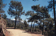
 The
Forest Station at Stavros tis Psokas is in the heart of the Pafos forest,
the largest and most beautiful pine forest (pinus brutia) of the island.
It can be reached from Pafos (51 kms), via Kannaviou, or from Polis
Chrysochous (34 kms). All forest roads leading to Stavros tis Psokas
are earth tracks, except for a section of the Kykkos - Stavros road.
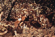
At the station there is a hostel (Tel. 02-352324) a cafeteria (Tel.
02-732512) and an organised picnic site. Nearby there is an enclosure
where visitors can admire the renowned Ovis gmelini aphion (Cyprus Moufflon),
and the Dama dama (a deer introduced to Cyprus from abroad).
The
Forest Station at Stavros tis Psokas is in the heart of the Pafos forest,
the largest and most beautiful pine forest (pinus brutia) of the island.
It can be reached from Pafos (51 kms), via Kannaviou, or from Polis
Chrysochous (34 kms). All forest roads leading to Stavros tis Psokas
are earth tracks, except for a section of the Kykkos - Stavros road.
At the station there is a hostel (Tel. 02-352324) a cafeteria (Tel.
02-732512) and an organised picnic site. Nearby there is an enclosure
where visitors can admire the renowned Ovis gmelini aphion (Cyprus Moufflon),
and the Dama dama (a deer introduced to Cyprus from abroad).